Springbrook / PL566
About Springbrook / PL566
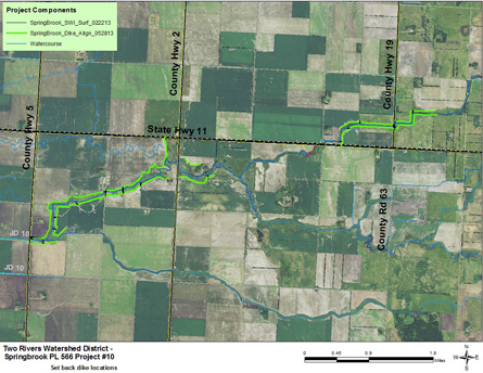
The project is located roughly 9 miles west of the City of Karlstad, MN. It follows an existing watercourse for a length of 9 miles. The watercourse serves as the outlet for Kittson County Ditch 10 and in turn outlets downstream into Judicial Ditch #10. Severe and repeated out of bank flooding have caused infrastructure and cropland damages, erosion problems, and excess sedimentation. The project consisted of constructing set back dikes to the 10 year flood elevation along the lower reaches of the watercourse to prevent future out of bank flows and overland flooding. It also implemented environmental improvements, including creation of a grass buffer corridor. Twenty eight side water inlets were installed, each consisting of a culvert through the set back dike with a flap gate on the 'wet' side. Funding for 300 acres of the riparian buffer was secured through the RIM program and the remainder of the project through other sources.
The project was planned, designed, and built using funding and expertise under the federal PL 566 program through the Natural Resources Conservation Service. NRCS planners, economists, and engineers assisted the Two Rivers WD with the project and NRCS contributed $1.3 million for construction. The State of Minnesota through the DNR’s Flood Damage Reduction grant program also contributed $160,000
Project Benefits Flood Damage Reduction: Set back dikes protect public infrastructure (roads, culverts, ditches) and cropland from overland flooding. The historically erosive watercourse that serves as an outlet for City of Karlstad storm and sanitary sewers was stabilized.
Natural Resource Enhancement: Protection of stream for 9 miles, creation of 300 acres of riparian buffer, habitat for migratory waterfowl, enhance fish migration and restoration of aquatic and upland habitat.
Water Quality: Reduction in channel erosion and bank sloughing, upland buffer establishment thus reducing effects of agricultural runoff. Reduce turbidity and suspended solids in the Red River and its tributaries.
A public hearing was held January 2, 2014.
For a printable copy of the assessment area map, click here.
-
Ditch Balance: Negative ($61,577)
-
2024 Levy: $15,000
-
Surveyed: 2021
-
Beavers Removed: 2022
-
Future Possible maintenance: Spraying and Beavers
-
Ditch Lien: $13,733 per year until 2029
Photo Gallery
.jpg)
The upstream end of the Springbrook #10 PL 566 Project
.jpg)
View of the project just downstream from Kittson County Road #19
.jpg)
View of the project north of MN State Highway #11